Sights

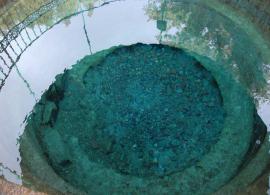
Douglas DC-3 aircraft

07/26/1941 Douglas DC-3 crashed into Lake Sig. The transport aircraft without cover remained at low altitude from the attacking Messerschmitts caught on the water and drowned. Of the 17 people saved 10. At the moment the aircraft is at the bottom of the lake, used as a rack.


Douglas DC-3 (Douglas DC-3, also known as C-47, C-53, R4D and Dakota) is a short-range passenger aircraft with two reciprocating engines.


Distance from the Ecocomplex: 
6.00 км
57° 1' 49.2132" N 33° 9' 38.1636" E

Bunkers of the Great Patriotic War

DOT - Long-Term Fire Point of the Great Patriotic War. These pillboxes were part of the Rzhev-Vyazma defensive line. The boundary was a system of moves and trenches (the remains were preserved in the forest), supplemented by fire points, and had several levels. On this defensive line were placed high hopes, therefore, during its construction, which began in July 1941, a huge number of people were involved. People worked in any weather and even under enemy fire from the air.

Distance from the Ecocomplex: 
8.00 км
57° 4' 6.2508" N 33° 2' 25.134" E

Ostashkov

Known since the XIV century. In the charter of the Lithuanian prince Olgerd to the Patriarch of Constantinople Philothe, dated 1371, is mentioned Klichen - a frontier town of the Moscow principality, located on the same island on Seliger. In 1393, Klichen was captured and burned by the Novgorodians. According to legend, after that, the only resident of Klichin, fisherman Eustafy (Ostashko), survived, who moved to the neighboring peninsula south of Klichen - from him the city and got its name.


Distance from the Ecocomplex: 
8.60 км
57° 8' 39.5808" N 33° 6' 47.9556" E

Fish Museum

In the town of Ostashkov, on the basis of the hotel complex, which stretches along the shore of Lake Seliger, the Pisces Museum was opened. The museum has become a kind of educational center, whose visitors learn about the peculiarities of this unique lake and the fish that inhabit Seliger. Exhibits of the museum tell about the history of fishing, which was considered traditional for the inhabitants of Ostashkov.

Distance from the Ecocomplex: 
8.90 км
57° 8' 42.252" N 33° 7' 0.8904" E

Znamensky nunnery

Ostashkovsky Znamensky nunnery appeared on the wasteland of Old Strugovishche, or Ubogoe, north of the city walls. This place was revered sacred - there were buried wanderers and fools. Immediately settled nuns. In the description of the Znamensky Monastery it is said: "... in 1655 there were 23 of them nuns and the main among them were Paraskeva and Golendukha. Patriarch Nikon, who was passing through Ostashkov this year, granted them alms to every old man by the hryvnia ... "(Uspensky V." Description of the Ostashkovsky Znamensky Monastery. "Tver, 1890, p.8).


Distance from the Ecocomplex: 
9.50 км
57° 9' 6.7896" N 33° 6' 32.4" E

Chapel of the Nile of Stolbensky

Chapel of the Nile of Stolbensky - the first church building, built in Ostashkov after 1917.


The chapel was built in memory of the Ostashkov residents, who died for their Motherland. Of the ten thousand remaining who fought on the fronts of the Great Patriotic War, more than six thousand died in battle.


On May 2, 2002, on the site of the future chapel in the square of the neighborhood, a memorial plate was opened and consecrated.


Distance from the Ecocomplex: 
9.90 км
57° 9' 19.9908" N 33° 6' 2.7108" E

Monument to the Partisans

At the initiative of the inhabitants of the city and nearby villages, an offer was made to perpetuate the memory of the Ostashkovsky partisans who perished during the Great Patriotic War.


The order to create the monument was given to sculptor Alexei Ilich Taneta. Work on it lasted more than 10 years. August 31, 1958 the monument was opened.

Distance from the Ecocomplex: 
10.40 км
57° 9' 22.7664" N 33° 6' 3.9744" E

The Valsky Pillar

From the history of the city it is known that the city was twice built up with a wooden defensive wall. She burned several times, rebuilt, but after the fire of 1711 the people refused to build a fortress. The architectural ensemble of the city fortress consisted of three important towers in economically defensive terms, which served as customs: Southern, Eastern and Northern. On the ashes of these towers, the grateful people built three bowing pillars in order to edify the descendants of the existence of the once stronghold.

Distance from the Ecocomplex: 
10.40 км
57° 9' 30.9564" N 33° 6' 5.9472" E

House of Artists Mitin-Potapov 30-40 years of XIX century.

Classicism dominated Ostashkov's residential architecture until the last quarter of the 19th century. The House of Artists Mitin is the most refined building of this type. The basis of the artistic appearance of this two-story mansion with a mezzanine is a four-column Ionic portico that distinguishes the center of the building.

Distance from the Ecocomplex: 
10.50 км
57° 9' 30.9888" N 33° 6' 4.2012" E

Local History Museum

For any person, and even more so for a historian, the Ostashkov museum of local lore is a real find! According to modern data, this museum is one of the oldest on the Tver land. Its creation dates back to 1889, when a small museum was opened in the city school, organized with the assistance of the teacher-inspector PA Shubyakov and other enthusiastic amateurs and connoisseurs of Ostashkov's antiquity.


Distance from the Ecocomplex: 
10.60 км
57° 9' 41.2164" N 33° 6' 7.6284" E

Resurrection and Trinity cathedrals
Distance from the Ecocomplex: 
10.60 км
57° 9' 40.5324" N 33° 6' 5.9148" E

Zhitenev Bogoroditsky female monastery

The Ostashkov Monastery is located near the town of Ostashkov on one of the islands of Lake Seliger, called Zhitenniy. Until 1700 on this island there were barns for grain stocks, collected by the Office of the Patriarchal Court from the inhabitants of the adjacent island of Klichno, who subsequently founded the town of Ostashkov. With the city the island is connected by a rampart.

The foundation of the monastery was laid in the beginning of the XVIII century, by the decree of the Emperor Peter the 1st of March 19, 1716.

Distance from the Ecocomplex: 
11.80 км
57° 10' 3.3564" N 33° 5' 36.2256" E

A rowan grove on the island of Klichen

On the island of Klichen on Seliger there is a miracle of the plant world - a rowan grove. It is especially beautiful here, of course, in the autumn, when the mountain ash grows. The nature of the island is extremely picturesque. The inner lake breathes peace and quiet. A unique sand spit flows smoothly into the waters of Seliger for more than a hundred meters. This is the only beauty, in its way, a place on the lake, attracting travelers here. The very name "Klichchen" is traditionally derived from the word "cry".

Distance from the Ecocomplex: 
13.40 км
57° 10' 52.2048" N 33° 5' 10.9032" E

Lake Seliger

Seliger is a system of lakes of glacial origin in the Tver and Novgorod regions of the Russian Federation. Another name is Ostashkovsky, named after Ostashkov on the lake shore.


The area of ​​the lake is 260 km ², including about 38 km² in islands (there are more than 160 on Seliger). The largest is Khachin.


The area of ​​the whole basin is 2275 km ².


Distance from the Ecocomplex: 
14.30 км
57° 11' 37.842" N 33° 5' 33.1548" E

Museum of Natural History

The only museum in the field of nature. Opened on July 5, 1986.


The exposition of the museum acquaints with various natural complexes of the Seliger region, with its plant and animal world. Particular attention is drawn to the picturesque dioramas of spruce forests, the deep-water part of Lake Seliger, the lair of the wolf.


Distance from the Ecocomplex: 
19.30 км
57° 5' 47.5224" N 33° 15' 37.3284" E

The Pyramid of Professor Golod

The Pyramids of Golod is an architectural structure made in the form of a regular tetrahedral pyramid. They are a constructive version of the so-called energy pyramids, using the proportion of the golden section as a shaping parameter, which provides the possibility of accumulating (speculating) the hypothetical anomalous energy caused by the shape of the pyramid. A distinctive feature of the use of the golden section in the Famine pyramids is its application to the ratio of the diameters of neighboring balls that are successively inscribed in the pyramid.

Distance from the Ecocomplex: 
19.40 км
57° 6' 9.3276" N 32° 56' 37.968" E

Khachin Island

Khachin is the largest island on Lake Seliger.


The area is more than 3 thousand hectares. From north to south, its length is about 9 km. From west to east 6 km.


The island is inhabited by bears, moose, wild boars, badgers, foxes, raccoons, rabbits, muskrat, beavers. Of waterfowl birds, it is necessary to note a bittern, a rather rare bird, which has chosen itself for nesting the coast of the island.


Distance from the Ecocomplex: 
22.00 км
57° 16' 4.6164" N 33° 2' 19.1184" E

Bogatyreva Mountain

The Bogatyr mound stands at Lake Sig, between the villages of Stary Sig and Kulatovo. The mound is called Bogatyreva Mountain. In the legends that are told here, this Sigovsky Gulliver was so huge that he put people in pockets.

Distance from the Ecocomplex: 
28.80 км
57° 1' 4.242" N 33° 11' 4.9236" E

Church of the Presentation of the Blessed Virgin in the Temple

The village of Kravotyn is very ancient. In the XVI century, it became the center of the volost and more than once figured in various documents. For example, it is known that when these lands were owned by Boyar Volsky, in the village there already existed a wooden church of the "Introduction of the Most-Holy Mother of God to the Temple". Its name was preserved for many years, and the church, built again at the end of the 18th century, was dedicated to the same holiday.

Distance from the Ecocomplex: 
34.40 км
57° 16' 40.9332" N 33° 8' 18.474" E

Nilov Monastery (Stolobny Island)

In clear weather with Gorodomly one more island is easily seen - Stolobny, on which there is a monastery of Nilov Deserts. The island is small, flat, and the monastic buildings seem standing right on the water. When you approach the island by boat or on a boat, the monastic constructions begin to rise from the water before your eyes, resembling a theatrical scenery.

Distance from the Ecocomplex: 
34.50 км
57° 14' 6.9648" N 33° 3' 43.0056" E

Orthodox church of the Exaltation of the Holy Cross

The church in Khotoshino is located away from the village, on top of a small sloping hill, around which the fields are spread. It was built in 1878 at the expense of the parishioners. Around the church was a fence, from which only the gates survived. The building of the church is brick. The volume-spatial composition of the building - three-part, consisted of a besstolpnogo, one-headed, two-lighted chetverik.


Distance from the Ecocomplex: 
36.60 км
56° 54' 5.8896" N 33° 18' 13.968" E

Seligersky ant area, Botovo

Not far from the villages of Botovo, Konets and Sloboda, there is an isolated forest area of ​​more than 300 hectares. It includes spruce forests-green-mushrooms, in which sour cherries, blueberries and many mushrooms. In this forest there are more than 200 anthills. The main mass is made up of nests of a red forest ant. The average diameter is 2.2 - 2.5 m, and the height of some reaches 2 m.


Distance from the Ecocomplex: 
39.20 км
57° 9' 37.008" N 33° 1' 11.1324" E

Vestibule of the Osprey on Lake Sonino

A unique object of wildlife.


Scopa Eurasian (Pandion haliaetus L.) - a rare species, which declines in numbers. In the Tver region. the population of the species is estimated at about 30-40 breeding pairs.


Since 1986, in the vicinity of Lake Sonino, there are several pairs of nesting here in the Osprey. To preserve the local natural balance in the ecosystem of the forest-lake-marsh complex, it was decided to take this place under environmental protection, endowing it with the status "Nature Monument".

Distance from the Ecocomplex: 
40.00 км
57° 13' 28.8732" N 33° 26' 1.3164" E

Lake Vselug

Vselug is a lake in the Tver region of Russia, on the Valdai Upland. The area (together with Lake Peno) is 37 km², the length is 14 km, the width is up to 4 km. The average depth is 7.7 m, the largest - 16 m.


Via Vselug passes the upper course of the Volga River after leaving the Lake Sterzh. The lake is a ples (an extension of the river). The coast is flat, along the coast stretches a shallow width of 15-20 m, composed of pebbles and boulders.


It is regulated by the Upper Volga Beyslot.


Distance from the Ecocomplex: 
40.00 км
57° 4' 53.2956" N 32° 40' 45.0588" E

The Tolstoy Estate in Novye Yelets

In the heart of Russia - in the Tver region, near the village of Yeltsy, on the picturesque peninsula near the Eletski ples of Lake Seliger, there is an old estate New Yeltsy, built at the end of the XVIII century, owned by the Tver landlords Tolstoy (from the far branch of the family of Count Tolstoy). They raised their pedigree to the legendary Indres, who left Chernigov from the German lands in 1353 with two sons and a large squadron, who adopted the name of Leontius at the baptism.

Distance from the Ecocomplex: 
41.60 км
57° 17' 7.71" N 32° 54' 26.3484" E

Memorial "Ksty"

Monument to the inhabitants of the village of Ksta, shot and burned on January 9, 1942. The memorial complex "Ksty", opened May 5, 1985 in memory of the victims of the tragedies in the village of Ksty, where 78 civilians and Ionovo khutor died - 9 people died. Sculptor I.D. Brodsky, architect I.A. Pokrovsky.

Distance from the Ecocomplex: 
43.50 км
56° 56' 53.9268" N 32° 42' 54.8352" E

Lake Peno

Peno, - a lake in the north-west of the Tver region of Russia, in the Penovsky district, one of the Upper Volga lakes located in the upper Volga.


Distance from the Ecocomplex: 
45.50 км
56° 55' 54.4584" N 32° 42' 37.5336" E

Shirkov Pogost
Distance from the Ecocomplex: 
46.10 км
57° 6' 25.7292" N 32° 38' 16.458" E

The Upper Volga Dam

The Verkhnevolzhsky Beyshlot is a dam in the upper reaches of the Volga River, forming the Upper Volga Reservoir, which unites the Lake Volgo, Lake Peno, Lake Vselug and Lake Sterzh into a single basin. Located 5 km below the place where the Volga flows from Lake Volgo.


The length of the dam is 46 meters, the average annual flow of water is 29 m³ / s, the annual fluctuation of the upper beech level is up to 3.5 meters, the lower one is about 0.1 m.


Distance from the Ecocomplex: 
46.90 км
56° 53' 8.1384" N 33° 19' 2.7048" E

Place of hermitage of St. Nil of Stolobensky

He was born at the end of the 15th century in the Zhabensky Pogost of the Derevskaya Pyatiny of the Novgorod Land; about his parents and the worldly name of the information is not preserved. At an early age he orphaned and came to the Krypetsky Monastery, where he took a monastic vows with the name Nile in honor of the Monk Nile Postnik. After living in the monastery for a while, Neil left him and in 1515 came to the forest near the river Cheremkhi (Seremkhi), where he built himself a cell in which he lived a hermit for 13 years.

Distance from the Ecocomplex: 
49.90 км
57° 22' 56.1288" N 33° 14' 18.5064" E

Church of the Assumption of the Blessed Virgin Mary

The building history of the Assumption Church in the village of Shchuch'ye does not differ from the history of many rural churches. After the wooden Nikolsky church burnt down in 1778, the construction of a stone church began. First, in just one year, the refectory was built with the southern St. Nicholas chapel, and the temple dedicated to the feast of the Aspen was completed until 1790.

Distance from the Ecocomplex: 
50.40 км
57° 22' 26.2452" N 33° 24' 25.614" E

The source of the Western Dvina

The Western Dvina is a river in Eastern Europe. The Western Dvina flows through the territory of the Russian Federation, Byelorussia, and Latvia. 1020 km, the basin area is 87.9 thousand km2. Begins on the Valdai Revolt, flows into the Gulf of Riga of the Baltic Sea, forming a delta. The average water discharge is 678 m3 / s. It is connected by the Berezinsky water system (does not work) to the Dnieper. It is navigable on certain sections. Another name for the river is Daugava and is translated from Latvian as "a lot of water".

Distance from the Ecocomplex: 
59.70 км
56° 52' 15.3552" N 32° 31' 56.0496" E

Church of the Transfiguration

The Church of the Transfiguration of the Lord was founded in 2000, as a chapel chapel before the re-creation of the Church of the Resurrection of Christ and the Nativity of the Virgin. Consecrated in 2002 by the Archbishop of Tver and Kashinsky Viktor.


The temple was built from larch, brought from the Arkhangelsk region, in a fairly short time, and thanks to the efforts of the builders and the help of the parishioners and sacrifices, the work was carried out all year round, without stopping either in the rain or in the cold frost.


Distance from the Ecocomplex: 
66.80 км
57° 18' 19.7892" N 32° 47' 31.6932" E

Berezovsky fortified settlement
Distance from the Ecocomplex: 
68.10 км
57° 18' 21.6468" N 32° 47' 18.402" E

Lake Volgo

The Volga is a lake in Selizharovsky, Ostashkovsky and Penovskiy districts of the Tver region of Russia, 25 km to the south of Ostashkov, the largest in the system of the Upper Volga lakes in the Valdai Upland, the fourth and last of the group of lakes through which the upper reaches of the Volga River passes is regulated by the Verkhnevolzhsky Beyshlot.


Distance from the Ecocomplex: 
68.30 км
56° 55' 57.8532" N 33° 8' 57.084" E

Seliger Ignace Cross

According to the chronicle in March-April 1238, the Tatar-Mongolian army, after conquering and ruining Torzhok, moved towards Novgorod. However, after reaching the Ignaz Cross site, about 200 km south of Veliky Novgorod, the Mongols refused to attack and turned back to the steppes, ravaging their villages on the way.


Distance from the Ecocomplex: 
69.00 км
57° 19' 59.8188" N 32° 37' 34.5252" E

Monument to the soldiers of the 1st, 3rd Shock Army

In memory of the soldiers of the 1st, 3rd shock army of those killed in the battles for the liberation of our Motherland in the period from 1942 to 1943.

Distance from the Ecocomplex: 
70.30 км
57° 17' 35.6424" N 32° 49' 22.908" E

Lake Sterzh

Sterzh is a lake in the Ostashkovsky district of the Tver region of Russia, the third largest in the system of the Upper Volga lakes in the Valdai Upland, the first of a group of lakes through which passes the upper course of the Volga River. Sterzh means "a quiet lake".


The length is 12 km, the width is up to 1.5 km, the average depth is 5 m, the largest is 8 m. The area is about 18 km².


The shores of the lake, which is a typical Seligersky stretch, are relatively high, the bottom and banks are sand and pebbles.


Distance from the Ecocomplex: 
71.00 км
57° 12' 9.8784" N 32° 35' 21.8256" E

Monastery of the Solovetsky Wonderworkers of Saints Zosima and Savvaty

In 1701 on the island was founded the monastery of the Solovetsky Wonderworkers of Saints Zosima and Savvatia. In 1947 the church was blown up. Since 1995 - the center of religious pilgrimage. A wooden church and a priest's house were built over the monastery's only preserved structure - a boulder glacier. Novosolovetsky Island is one of such places in Russia, where one wants to return again and again.

Distance from the Ecocomplex: 
71.20 км
57° 2' 10.9932" N 32° 41' 34.5048" E

Lake Tryaskoye

  A unique crystal-clear "silver" lake. Transparency of water is about 10 meters. It does not bloom, you can drink from it without fear of getting sick.


Not connecting any channels with other lakes (Seliger, Sobenskie lakes), maintains a constant water level. Independently rainy or dry season. The phenomenon of this lake no one can explain to this day.


Distance from the Ecocomplex: 
72.20 км
57° 17' 32.298" N 32° 50' 56.8536" E

The Olginsky Convent

The monastery near the source of the Volga has its own history. It began with the construction of a stone church in the village of Volgo-Verkhovye. At the initiative of the inhabitants of the Volga cities, who wanted to celebrate the spiritual significance of the beginning of the great Russian river, a stone church began to be built on voluntary donations in the village of Volgo-Verkhovye. Great help was provided by the All-Russian Society of Saint Olga.


Distance from the Ecocomplex: 
74.90 км
57° 15' 5.3316" N 32° 28' 17.598" E

The source of the Volga

The Volga is especially loved by our people. Truly Russian natural miracle, the great river - mother, one of the largest on the planet and the largest river in Europe. The name Volga came from the Proto-Slavic Volga - the volga - moisture.

Distance from the Ecocomplex: 
75.10 км
57° 15' 5.2956" N 32° 28' 6.15" E

Church of the Smolensk Icon of the Mother of God Hodegetria

The Church of the Smolensk Mother of God Odigitrii in the village of Okovtsi was built on the site, according to legend, in 1539 a miraculous phenomenon occurred to local residents of two miraculous icons: the Life-giving Cross of the Lord and the Blessed Virgin Mary Odigitria. In January 1540, icons were brought to Moscow, where they were until July. Then they were returned to Okovtsy, where two small wooden churches were built on the site of their appearance.


Distance from the Ecocomplex: 
77.70 км
56° 39' 18.216" N 33° 29' 12.4296" E

Church of the Trinity of the Life-Giver in Perevoloka

On the Cowboy peninsula in alder thickets, the Trinity Church on Perevolok is visible. The very name of the church speaks volumes. In ancient times, there was fiber, where vessels dragged from one part of the lake to another narrow, not more than half a kilometer wide, by the isthmus, with which the peninsula is connected to the mainland. Circumventing the peninsula on oars or under sails, when the head wind blows, is not so easy, long, and sometimes dangerous. It was much easier to drag rooks from the reach of the reach.

Distance from the Ecocomplex: 
78.80 км
57° 17' 12.0552" N 32° 58' 10.362" E

Orthodox church of the Transfiguration

A stone church with a bell tower, built on the funds of parishioners at the end of the XVIII century. It was rebuilt in the XIX century. There was a parish school at the church. In the 1930s it was closed, abandoned.

Distance from the Ecocomplex: 
79.70 км
57° 24' 8.2476" N 33° 0' 34.3368" E

Holy Okovetsky spring

Each year, thousands of pilgrims rush to the Okovetsky holy key for healing. Water beats from under the ground all year round, and it is always cold, like Epiphany, - no more than 4 degrees of heat. A font and a chapel are built on the source, where water-molebens serve. Believers immerse themselves in the fertile water in the hope of regaining health and gaining strength.


Distance from the Ecocomplex: 
80.00 км
56° 39' 46.0188" N 33° 30' 18.792" E

Ancient settlement "Gorishin" (XI - XIII cc.)

In the vicinity of Seliger a number of settlements have a long history. Some of today's villages in the area, for example, the Upper Volga lakes were once fortified by Lithuanian towns.


From the beginning of XIII and until the end of the XVII century. on these places a wave of Lithuanian invasions was repeatedly rolled. Only in the XIII century. Similar incursions were committed in 1225-1227, 1245 and 1258gg. For their consolidation on the Upper Volga in the first of these invasions, Lithuanians built several small towns, one of which was Gorishin.


Distance from the Ecocomplex: 
81.40 км
56° 44' 57.4548" N 33° 40' 51.8988" E

Nature Monument "Goryshensky Hill"

It consists of two heights with a relative level from the water edge of about 35 meters. Their length both hills are stretched from west to east by 250-300 meters. On the hill there is the abandoned church of Nicholas the Wonderworker of 1783.


The very word "goryoshin" came from ancient times. It echoes the ancient symbol, the monster of Russian fairy tales - Gorynych. His antiquity goes to the same Sanskrit - in Avestian "garish" - mountain.

Distance from the Ecocomplex: 
81.40 км
56° 44' 54.6828" N 33° 40' 56.5248" E

The nature monument "Eletskaya Krucha"

The landscape is about 7 km long, resembles a mountain one. The speed of water flow in the Volga River in this place is 0 - 0.6 m / s. From the top of the hill opens an exceptionally picturesque view of the valley of the Volga River and surrounding forests. The hillside is occupied by a rich meadow grass with separate powerful old-aged pine trees.

Distance from the Ecocomplex: 
89.10 км
56° 39' 22.8816" N 33° 50' 18.906" E

The nature monument "Bienye rapids"

In the upper Volga is a fast and stony river. From Upper Volga lakes to Rzhev there are more than thirty rapids in it. The most famous Bensky Threshold is that near the village of Yelets, where for one kilometer the drop of water reaches three meters! The thresholds arose in the area of ​​the outlet to the surface of the lower carbonate limestone layers, which have increased strength due to marbling. Numerous whirlpools and breakers create a noise of water, which is heard at a great distance.

Distance from the Ecocomplex: 
92.80 км
56° 39' 11.5704" N 33° 46' 37.4736" E

Lake Brosno

Brosno is a lake in the north-west of the Tver region of Russia, in the Andreepol district of the Tver region. The lake belongs to the basin of the Western Dvina and the Baltic Sea.


The area of ​​Lake Brosno 7.2 km². Height above sea level is 243 meters, length is 10.8 km, maximum width is -4 km, average -2, length of coastline is 16.2 km. Lake Brosno is the deepest in the Tver region, its greatest depth is 41.5 meters, the average depth is 17 meters. The origin of the lake is hollow.


Distance from the Ecocomplex: 
127.00 км
56° 49' 1.6284" N 31° 57' 28.3068" E

Yazhelbitsyn Ignace-Cross

According to the chronicle in March-April 1238, the Tatar-Mongolian army, after conquering and ruining Torzhok, moved towards Novgorod. However, after reaching the Ignaz Cross site, about 200 km south of Veliky Novgorod, the Mongols refused to attack and turned back to the steppes, ravaging their villages on the way.


Distance from the Ecocomplex: 
179.60 км
58° 2' 56.94" N 32° 50' 24.18" E